Westchester Wind

The proposed wind energy project, called the Westchester Wind Project (WWP or Project), consists of
up to 12 wind turbine generators (WTGs) capable of producing up to 50 MW of renewable energy that
will be connected to the existing Nova Scotia Power transmission grid via an overhead transmission line.
The Project is being developed by Natural Forces Developments Limited Partnership (referred to herein
as the Proponent or Natural Forces) in partnership with Wskijnu’k Mtmo’taqnuow Agency Limited (the
Agency), a corporate body wholly owned by the 13 Mi’kmaq bands in Nova Scotia. Together, Natural
Forces and the Agency are developing the Project and they will co-own and operate the Project.

The purpose of this Project is to help Nova Scotia achieve their renewable electricity standards through
the generation of clean, renewable energy, and reduce Nova Scotia’s reliance on imported energy
sources through the development of a localized renewable energy generation (Renewable Electricity
Regulations 2021).
Location Description
The Project is located on a mixture of privately owner blueberry fields, previously forested land and
undeveloped forested land in Cumberland County near the communiƟes of Westchester StaƟon, Rose,
and Londonderry.
Project Status
Approved
Purpose
Local Grid
Onshore/Offshore
Onshore
Number of Turbines
12
Total Project Capacity (MW)
50.00
Commissioning Year
2024
Signed Offtake Deals
No
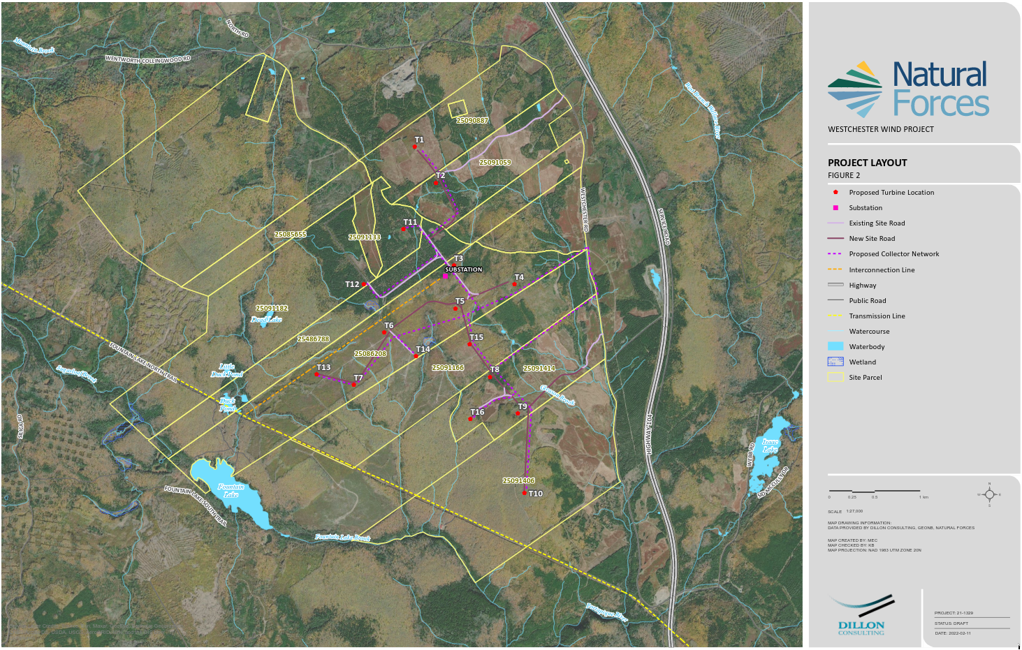
Proposed Site Plan

Nova Scotia Wind Turbines

This map is an attempt to document existing and proposed wind turbines in Nova Scotia

Areas outlined in yellow are the proposed project boundaries

Red dots represent turbine locations

Yellow areas with no dots are locations that I do not have turbine location data for

The data has been harvested from various project Environmental Assessment documents, company websites and databases from the Govt of Canada

Project boundary WKT polygons were created by overlaying company site plan images and tracing as best as possible... there may be discrepancies

Project boundaries that are represented as simple rectangular objects are projects that I do not have good data for so locations are estimated based on publicly available 'clues' as to locations

If any company would like to provide data for either project boundaries or turbine locations, I'd be happy to update the map

Use the map full-screen icon/control to get the best viewing experience

Turbines in this project

Turbine Model Rotor Diameter (m) Turbine Rated Capacity (kW)
WESTWIND1 45.582799, -63.747512 ENERCON E-138 EP3 E2 4 138.00 4200.00
WESTWIND2 45.579227, -63.744478 ENERCON E-138 EP3 E2 4 138.00 4200.00
WESTWIND3 45.571063, -63.741819 ENERCON E-138 EP3 E2 4 138.00 4200.00
WESTWIND4 45.569255, -63.733222 ENERCON E-138 EP3 E2 4 138.00 4200.00
WESTWIND5 45.56678, -63.741558 ENERCON E-138 EP3 E2 4 138.00 4200.00
WESTWIND6 45.564326, -63.751559 ENERCON E-138 EP3 E2 4 138.00 4200.00
WESTWIND7 45.559117, -63.755795 ENERCON E-138 EP3 E2 4 138.00 4200.00
WESTWIND8 45.560017, -63.736569 ENERCON E-138 EP3 E2 4 138.00 4200.00
WESTWIND9 45.556378, -63.732593 ENERCON E-138 EP3 E2 4 138.00 4200.00
WESTWIND10 45.548478, -63.731539 ENERCON E-138 EP3 E2 4 138.00 4200.00
WESTWIND11 45.574598, -63.748992 ENERCON E-138 EP3 E2 4 138.00 4200.00
WESTWIND12 45.569098, -63.754519 ENERCON E-138 EP3 E2 4 138.00 4200.00
WESTWIND13 45.560081, -63.761049 ENERCON E-138 EP3 E2 4 138.00 4200.00
WESTWIND14 45.561965, -63.747043 ENERCON E-138 EP3 E2 4 138.00 4200.00
WESTWIND15 45.563238, -63.7395 ENERCON E-138 EP3 E2 4 138.00 4200.00
WESTWIND16 45.555804, -63.739287 ENERCON E-138 EP3 E2 4 138.00 4200.00