Ellershouse 3 Wind Facility

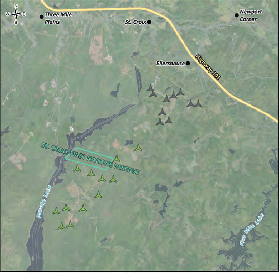
Ellershouse 3 Wind LP proposes to develop, construct, and operate the 66 MW Project located on
private land in the Municipality of West Hants, near the communities of Ellershouse and Hartville,
Nova Scotia (Drawing 2.1). The approximate center of the Project is located at 44.895753° N,
64.054422° W.

The Project will include up to 12 turbines generating up to 5.9 MW each (Drawing 2.2), access
roads, interconnecting transmission system, substation, connection to the Nova Scotia Power Inc.
(NS Power) grid, and the associated infrastructure for the aforementioned facilities.
The Project location was carefully selected due to excellent land and community partners, and
distance to existing electrical and civil infrastructure. The Project will interconnect to NS Power’s
transmission system through a direct line tap to the 138kV L-6051 transmission line, located
approximately 350 m from the proposed substation. The existing Ellershouse Wind Farm, which
consists of 10 operating wind turbines that are owned and operated by AREA, is located immediately
north of the proposed Project.

The Study Area1 consists entirely of private lands, which are currently utilized for forestry and
silviculture. Ellershouse 3 Wind LP has secured the land required for the Project through lease and
easement agreements on private properties owned and developed for forestry purposes.
Upon approval of the EA, construction activities are proposed to begin in 2024 and, once
constructed, the Project is expected to be operational in 2025 for a minimum of 25 years.
Location Description
Municipality of West Hants, near the communities of Ellershouse and Hartville,
Nova Scotia
Project Status
Proposed
Purpose
Local Grid
Onshore/Offshore
Onshore
Number of Turbines
12
Total Project Capacity (MW)
66.00
Commissioning Year
2025
Signed Offtake Deals
No
Proposed Site Plan

Nova Scotia Wind Turbines

This map is an attempt to document existing and proposed wind turbines in Nova Scotia

Areas outlined in yellow are the proposed project boundaries

Red dots represent turbine locations

Yellow areas with no dots are locations that I do not have turbine location data for

The data has been harvested from various project Environmental Assessment documents, company websites and databases from the Govt of Canada

Project boundary WKT polygons were created by overlaying company site plan images and tracing as best as possible... there may be discrepancies

Project boundaries that are represented as simple rectangular objects are projects that I do not have good data for so locations are estimated based on publicly available 'clues' as to locations

If any company would like to provide data for either project boundaries or turbine locations, I'd be happy to update the map

Use the map full-screen icon/control to get the best viewing experience

Turbines in this project

Turbine Model Rotor Diameter (m) Turbine Rated Capacity (kW)
ELL3-1 44.907, -64.037 Unspecified 162-5000 162.00 5000.00
ELL3-2 44.902, -64.049 Unspecified 162-5000 162.00 5000.00
ELL3-3 44.897, -64.072 Unspecified 162-5000 162.00 5000.00
ELL3-4 44.896, -64.064 Unspecified 162-5000 162.00 5000.00
ELL3-5 44.894, -64.059 Unspecified 162-5000 162.00 5000.00
ELL3-6 44.895, -64.052 Unspecified 162-5000 162.00 5000.00
ELL3-7 44.886917, -64.062329 Unspecified 162-5000 162.00 5000.00
ELL3-8 44.881, -64.08 Unspecified 162-5000 162.00 5000.00
ELL3-9 44.881, -64.07 Unspecified 162-5000 162.00 5000.00
ELL3-10 44.878, -64.085 Unspecified 162-5000 162.00 5000.00
ELL3-11 44.873, -64.078 Unspecified 162-5000 162.00 5000.00
ELL3-12 44.872, -64.084 Unspecified 162-5000 162.00 5000.00